Introduction
NCX helps landowners like you find the right programs for you and your land. There are a bewildering array of programs for landowners, but NCX’s technology helps narrow down your search by automatically determining the programs for which your property is eligible. Today, we are launching NCX Eligibility Maps to give you an even clearer picture of which acres of your land are eligible for each program.
Now, when you log in to your NCX.com account and click on the page for a program, you’ll see a new map that shows your property. There is an Eligibility layer that you can toggle on and off to see which parts of your property are eligible for that program. This map can help you determine if a program is a good fit for you.
For example, your land might be eligible for a solar project but when you look at the NCX Eligibility Map, you might discover that the eligible acreage is in your best pasture for grazing your cattle. You might have been interested if they had been able to use the steeply sloped part of your land, but when you look on the map, you see that those acres aren’t eligible for the solar project.
To make these maps, NCX is pulling in tons of satellite imagery and other datasets to evaluate your property against the unique eligibility requirements of each program. NCX runs this analysis in minutes as soon as you add your property to the NCX platform. In this post we’ll give you a peak behind the scenes to see how we make the map magic happen.
Case study:
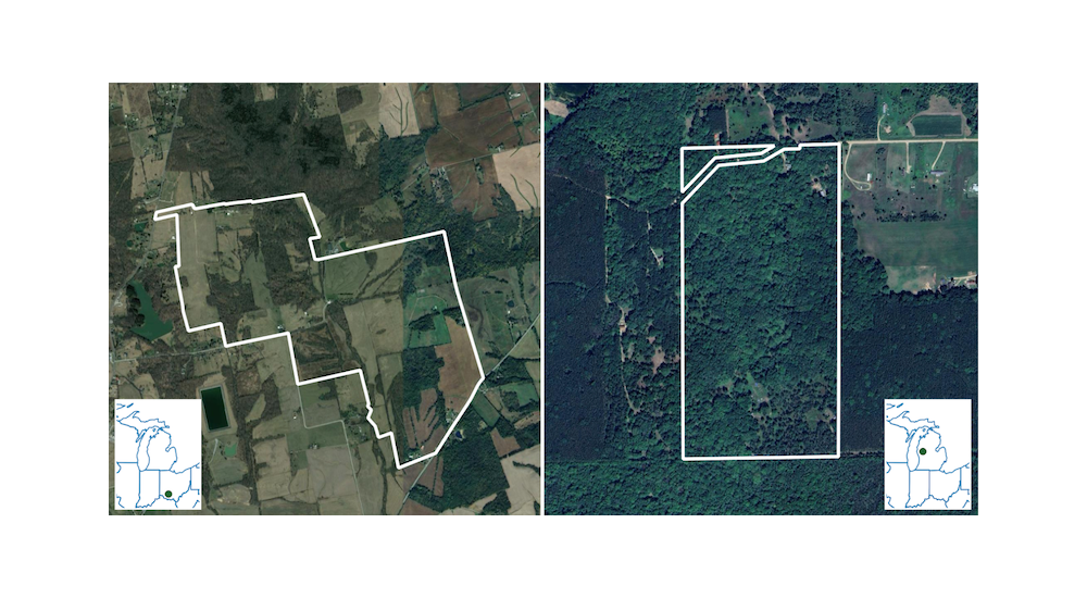
Imagine you are a landowner who lives on a 1000 acre property in Ohio and owns 80 acres of land up in Michigan that you use for hunting and recreation and maybe an occasional timber harvest. You grow hay on some parts of your property in Ohio and the rest of the property is forested. Your current situation is working well for you but you have an NCX account and have heard about opportunities for earning income from carbon credits by planting trees in non-forested areas.
The program you heard about involves planting trees in non-forest areas of the midwest and Appalachian regions (OH, PA, WV, and KY). To enroll in the program you need at least 300 acres of land that
a) you could plant trees on,
b) has not been forested in the last 10 years (to qualify for afforestation carbon credits), and
c) has slope < 30%.
We’ll now walk through a step-by-step explanation of how our algorithmic assessment instantly determines your eligibility for programs on the NCX marketplace.
Step 1: geography
The first step in determining if your property is eligible for a single program is to compare the location of the parcels to the program’s enrollment area. Some programs are available across the continental US but most are confined to a set of states or counties, so the first filter we apply is simple: is any part of the property within the eligible geography for this program? If not, we are done with that assessment. If it is in-bounds, we get to do the fun part: pixel-level analysis.

Good news! Your land in Ohio is within the eligible geography for this program! The land in Michigan is not eligible for this particular program.
Step 2: pixel-level analysis
Now that we have determined that part of your property is within the eligible geography, we need to perform a fine-grained assessment of your land. The qualifying criteria for this program are
- land cover appropriate for planting trees
- not forest, not developed, not open water, not wetland, etc
- has not been forested in the last 10 years
- slope < 30%
Each one of these criteria will require an assessment against a different data source (land cover, land use history, and topography) but the NCX assessment platform seamlessly combines all of the relevant data sources and can determine which exact parts of your property are probably eligible. The data sources that we use provide information at 30 meter resolution, or about 1/5 of an acre.
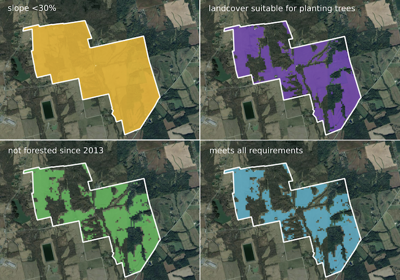
Based on NCX’s analysis of the land cover, land-use history and topography for your Ohio property, you have about 400 acres that are eligible for this tree planting program!
Step 3: summarize
Then we compare the total eligible acreage on your property to the stated minimum for this program. In this case, you are a great candidate for the program since you have 400 eligible acres - well above the minimum of 300 acres.
Step 4: take action!
Thanks to a rapid assessment of your property for the specific needs of this program, you are now free to request a call to discuss enrolling in the program. You are also able to evaluate alternative programs for your property right here on the NCX platform - we have done the same exact type of analysis for all of the programs listed on the platform and have outlined the most important program details to make it easy to compare all of your options.
Where does the data come from?
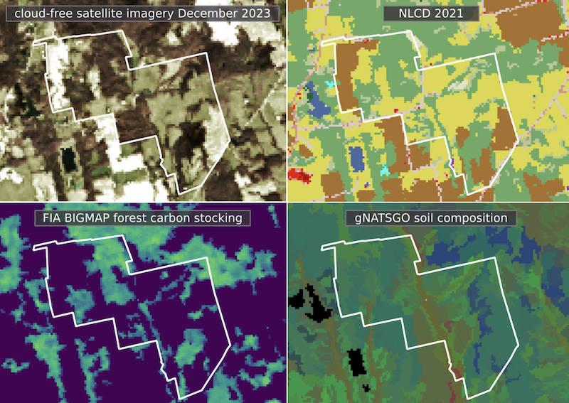
Our library of data layers contains government-produced land cover datasets like the National Land Cover Dataset (NLCD), satellite imagery like Harmonized Landsat Sentinel 2 (HLS), the US Forest Service FIA’s BIGMAP product, and much more. Our goal is to use the best data to answer the most basic questions about your land’s suitability for a wide variety of programs. We do the work with data so that when you are ready to review your options, it is clear which programs are the best fit for you and your land. When there are program requirements that cannot be adequately assessed remotely using data, we rely on the landowner to supply information via “attestations” on the platform. These interview-like questions are written to be as simple as possible while still providing the information required.
When we run into a program requirement that cannot be assessed from a readily-available data source we will add an “attestation” to the program page where a landowner can provide information about their property. One example of a requirement that we assess using an attestation is “does your property contain an internal road network that can be used for tree planting operations?” Most road layers will only include public road infrastructure, so private road networks are not usually included. We are always working to reduce the burden on landowners so we are constantly seeking out new data sources or building predictive models if that is the most efficient way to get the data.
We hope these NCX Eligibility Maps are helpful as you explore programs on the NCX platform. Log in or create a free NCX account today to see NCX Eligibility Maps for your property.